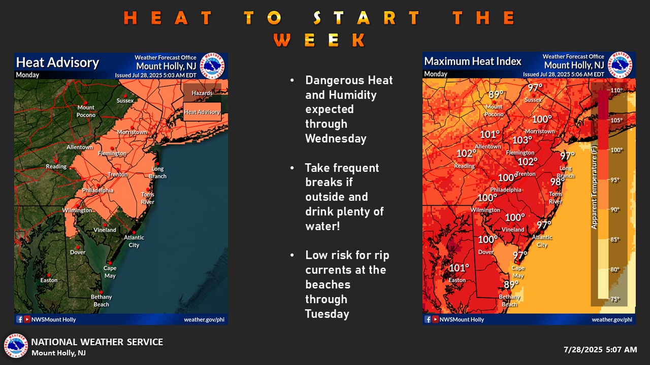
Through Wednesday, high pressure is predicted to bring potentially hazardous heat and humidity to the Lehigh Valley, according to the National Weather Services.
After Thursday’s preview night, a front is expected to gradually pass through Wednesday night through Thursday night, bringing milder temperatures but unsteady weather as Musikfest kicks off its 10-day run in Bethlehem on Friday.
The Lehigh Valley is expected to see generally clear skies overnight into Tuesday, with a high of 93 degrees on Monday and a low of about 70 degrees.
At Lehigh Valley International Airport, air temperatures are then expected to reach 96 degrees on Tuesday and 95 degrees on Wednesday. The meteorological service said that Friday’s record high of 96 was established at the airfield outside of Allentown, surpassing the previous record high of 95 for July 25 from 1949, 1999, and 2016. At the airport, Tuesday and Wednesday have record highs of 96 (1954) and 97 (1940).
With heat indices—a real-feel gauge of air temperature and relative humidity—possibly reaching between 100 and 105 degrees through Wednesday night, the National Weather Service has issued a Heat Advisory for Lehigh, Northampton, and Warren counties this week.
The Heat Advisory alerts locals to excessive heat and humidity and is in force from Tuesday at 11 a.m. until Wednesday at 8 p.m. Overnight lows are predicted to be humid in the low to mid-70s, while daytime highs will rise into the low to mid-90s. The oppressive humidity indicated by dew points of about 70 degrees intensifies the heat.
During this hazardous heat wave, residents are urged to exercise caution. Drink plenty of water, stay inside during the warmest hours of the day, and keep an eye on vulnerable groups including elderly neighbors, small children, and anyone with long-term medical concerns. Exercise and work outside should be avoided during the hottest parts of the day, and cool, air-conditioned areas are advised.
With the impending cold front that could bring heavy rainfall and sporadic thunderstorms, the heat wave is predicted to end on Thursday. High humidity will continue, but temperatures will return to the 80s. More comfortable weather is expected by Friday and into the weekend, with largely sunny skies and temperatures that could reach the mid 70s to low 80s.
The next weekend may be the best of the summer, according to long-term projections, with clear skies and below-normal temperatures that will relieve the present excessive heat wave.
AccuWeather’s local prediction can be found at lehighvalleylive.com/weather, and the National Weather Service’s watches, warnings, and other advisories may be found at lehighvalleylive.com/weather-alerts when they are issued.
Current weather radar
Your support is essential to our journalism. Please sign up for a subscription to lehighvalleylive.com now.
Kurt Bresswein, the supervising reporter, helped write this piece. [email protected] is his email address. Parts of this report were drafted using generative AI and vetted and modified by the crew of lehighvalleylive.com.